 |
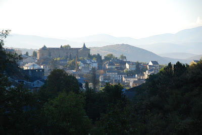
| Villafranca del Bierzo |
Today we get an early start at 8:30 to bus back to Villafranca del Bierzo and pick
up where we left off. Alex briefed us last night that it will be difficult and
longer, with an uphill climb of a couple thousand feet at the end to O Cebreiro
which sits on the top of a hill.
Many of
our number are looking to use the van for part of the way today. All of us are calculating whether this will be too difficult.
Our path out of Villafranca del Bierzo leads along the Valcarce river and a
highway into or out of town.
There a few
pilgrims out, and a few vehicles in the cool morning air.
The mountains around us are high, so the
sunlight is only hitting the higher hills. We are in shadows.
We all are
walking at a much faster pace today.
It occurred to me that perhaps we were going
too slowly yesterday. We got passed by so many pilgrims, and we passed very few
if any ourselves.
I suspect the newness
of the experience, the many opportunities to take photos, and the diverse conversations
slowed us yesterday. Perhaps also we know that this will be a more difficult
day because of the altitude we must climb to O Cebreiro. But at the start it is
pretty flat.
 |
| Pareje - the balcony |
We barely paused at Pareje, which had the longest balcony in northern Spain
(per my guidebook, which tends to provide such random facts) and a
bar/restaurant where we got a stamp and some used the facilities.
There was much discussion of the words
“servicios” and “WC” and how to pronounced them in Spanish.
If people keep asking for the
baño someone will get a bath. We kept
walking up along the national highway on a side path that once was painted
yellow for the pilgrims.
It’s now quite
faded, perhaps in recognition that the new super highway above us has taken
most of the traffic away from this local two-lane highway.
There was a coffee stop and checkpoint in Trabadelo, and then continued
on.
There was a nice little stone church
with Romanesque influence there, so we again got stamps.
As we walk along,
there are cows with their bells and some
horses along the way, but farms seem small and there are almost no grape vines
at all.
It is surprising how the vino
culture dried up as soon as we left Villafranca del Bierzo.
There are lots of signs about fishing in the
river, including many areas that are “catch and release” but also some river
banks that are “prohibido de pescar” entirely.
The swift little river Valcarce is our constant companion, usually
shaded, often surging along, and a little lower down on our left side.
I spoke today more with other pilgrims who are not part of our group.
Coming out of Trabadelo I struck up a
conversation with a young Spanish girl who had just finished her university
degree and who wanted to start a “
casa
rural” type of guest house with her “
novio.”
We talked about the American movie about the
Camino, “The Way,” which she had not seen.
Surprisingly, it has not been released yet in Spain, she said. (Later
Alex told me it has been released, but for unexplained reasons made little impact among Spaniards here.)
I also talked with some Germans, a father and son team who had biked part of
the way and were now walking more of the Camino. There were others with whom I
had shorter conversations or listened to as we walked together.
Then there were the Austrians we talked about
skiing with. Most of the Europeans can speak English, but Spanish is also often
a lengua franca.
 |
| Saracen castle on the hilltop |
I began to hope for a lunch stop as soon as I saw the sign saying “Vega de
Valcarce 1 km.”
First that was an
overlong one kilometer, and then we walked through the entire town without
finding our bus, Celso, or lunch.
I did
spot the ruins of the Saracen castle on the bluff overlooking the town, but
that was little satisfaction because it was far too high to climb up and look
at.
Eventually we did come to Alex in the
road, who assured us that it is “just ten minutes” ahead to the lunch
stop.
It was in fact almost to the next
village, but it was fine when we got there and found Cate’s luncheon
preparations. Ah, a chance to sit down!
After lunch, we began the much anticipated climb.
It started simply enough as we turned off the
national highway and onto a small asphalt road that wound through Las
Herrerias. That soon turned into a winding path that ascended through a forest
of trees.
The
camino did however become steeper and more rocky as we went
up.
There were few other hikers seen,
but we did pass a couple of people, including one couple where the girl was
struggling – so much that Carl gave her a pull up the hill. (Don’t know how her
boyfriend felt about that, but he was laboring under a large pack and was in no
position to object.)

The hill just keeps going up, and at a considerable incline.
I used my walking poles to good effect, and I
was glad I had shed my back pack and carried only my camera and a bottle of
water. You fall into a rhythm of sticks and feet, a steady pace, up and up.
There really were not many pictures to take
at this stage because all our effort went into the climb.
It got real steep and rocky.
I was
walking up with Carl, using both sticks and leaning forward.
Just keep that rhythm going, putting one step
after another. We stopped once in a while in the shade to catch our
breath.
Fortunately, we were shaded by
trees over the path most of the way.
Finally, at Laguna, where one should begin to see “horreos” but we
don’t, about two or three miles before the finish, the tree cover opened up and
we had great views out across the valley and toward the mountains in the
distance. I found myself with Pat and Leslie and Maria.
Maria of course wanted to run up the path!
Finally, still climbing, we see the bus parked in a lot to one side.
But we could see that the top of the hill was
to the right, so we perversely insisted on going up there.
Having climbed this far, nothing but the top
will do.
We took pictures, made bets
about the altitude and the temperature, and savored the hard-earned views in
the afternoon sun.
Our accomplishment, as we stand on the hill above O Cebreiro, is a measured
total of 18.6 miles walked in six hours and 16 minutes of moving time, and we
reached an altitude of
4272 feet.
We started the day at about 1900 feet.
We never could figure out the air
temperature, but it must have been about 65.
Below us, near the chapel and the rectory are the round, thatch-roofed “
pallozas” that were the combination home
and barn for early Galician people in this area. Our hotel is in fact the former monastery, and we're in the monks cells -- well, probably two monk cells per modern room. And, each room has a bathroom with shower -- something the monks probably did not enjoy.
Dinner at the monastery, after evening mass, was quite good, if a bit rustic.


 The hill just keeps going up, and at a considerable incline. I used my walking poles to good effect, and I
was glad I had shed my back pack and carried only my camera and a bottle of
water. You fall into a rhythm of sticks and feet, a steady pace, up and up. There really were not many pictures to take
at this stage because all our effort went into the climb.
The hill just keeps going up, and at a considerable incline. I used my walking poles to good effect, and I
was glad I had shed my back pack and carried only my camera and a bottle of
water. You fall into a rhythm of sticks and feet, a steady pace, up and up. There really were not many pictures to take
at this stage because all our effort went into the climb. 


No comments:
Post a Comment